
|
|
| Home | Area of Emphasis | Research Activities |
|
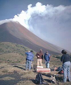
Remote Sensing for Hazard Mitigation and Resource Protection in Pacific Latin America, Emphasis Area: Volcano/Atmosphere Interactions Principal Investigator(s): G. Bluth (PI), J. Gierke, E Gross, and W. Rose, (Co-PI’s) Sponsor: NSF Office of International Science and Engineering Funding Level: $2,300,000
Period: 9/2005 to 8/2010
Abstract:
Abstract: This project focuses on developing remote sensing tools and validation methods for hazard mitigation and resource protection in Guatemala, El Salvador, Nicaragua and Ecuador. We are working towards two important goals: (1) to develop a formal linkage among geoscience agencies in the four countries, focusing on the collaborative development of remote sensing tools for hazard mitigation and water resource development; (2) to build a new educational system of applied research and engineering, using two existing educational programs at Michigan Tech: a new Peace Corp/Masters International program in Natural Hazards which features a 2-year field assignment, and an undergraduate Enterprise program, which gives teams of civil, environmental, and geological engineering students the opportunity to work on real-world problems over multiple years in a business-like setting.
Last Update: October 11, 2007 If you have any problems or comments, contact the webmaster. Email Webmaster ehgroth@mtu.edu |
 Emphasis Area:
Volcano/Atmosphere Interactions
Emphasis Area:
Volcano/Atmosphere Interactions